|
An introduction to GPS!
There are several different types of GPS (Global Positioning System) available for a variety of applications. Originally developed for use by the U.S. Military, the GPS system consists of a network of satellites surrounding the globe that continually transmit signals that can be detected by a compatible receiver.
The GPS receiver that most of us use incorporates the ability to lock on to three of these satellite signals to triangulate the current position of the unit. This information is converted into useful data depending on the specific user requirements.
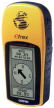
Personal GPS units such as the Garmin eTrex are designed primarily to provide Stationary Information. For public safety applications, these units are sold by Falcon Wireless to emergency medical providers who use them to determine their current location in geographical coordinates (Latitude and Longitude). This information is sent to a rapid response medical helicopter that has an onboard computer system to calculate the travel path and estimated arrival times.
Priced at only $149.99, the eTrex can be purchased at the Falcon Wireless on-line store at http://falconwireless.goemerchant7.com. At this low price, the eTrex is also very popular for personal use. Hunters, hobbyists, and others can use the eTrex for obtaining direction between the present location and a previous starting point or calculate directions to a new destination. All over the USA, clubs have been formed that conduct treasure hunts. We use the eTrex for determining coordinates and elevation information used in preparing FCC license applications. The applications are virtually unlimited. More detailed information on GPS system is available at http://www.aero.org/publications/GPSPRIMER.
As you can see, the Stationary Information GPS system provides a variety of solutions for a number of applications. This application in a more advanced form is now found in many vehicles that incorporate the basic GPS technology along with mapping software to provide trip planning, trip records, and directions.
There is a second application for GPS known as Administrative Reporting. This adds another dimension to the usefulness to GPS. The aforementioned, the Stationary Information use of GPS deals primarily with current status by and for the user.
Administrative Reporting systems are used to accumulate vehicular trip data for
administrative review at the end of a trip, work period, or shift. These systems are primarily used by Law Enforcement agencies for purposes of documenting activities by vehicles assigned to patrol activities.
Service companies also use this technology since it is capable of providing simple reports on each vehicle showing the number of stops and duration along with travel and speed information. The payback in terms of improved efficiency, litigation avoidance, and conflict resolution comes very quickly as the equipment is affordably priced ($700 per vehicle and $1,400 for the office unit for our own SilentPartner system).
Our SilentPartner system is one of the more popular technologies used for Administrative Reporting. An overview of this system and an actual case study by a police department can be found by going to our primary web site at www.falcon4u.com. Click on the POLICE icon. This will direct you to our law enforcement web page. Once you are there, click on the SILENT PARTNER taskbar selection for additional information.
Live Location Reporting or LLR, is a third type of GPS system. LLR has been around for a number of years. Law enforcement users use LLR to provide current vehicle location information, both for administrative use, as well as an enhancement for officer safety, and computer aid dispatch systems.
There are two basic types of LLR systems. The first is known as Streaming LLR which means that data is flowing from the mobile on a constant or near constant basis to provide continual location reports on a display screen. Actually, the systems are programmed to send information at timed periodic intervals ranging from just a few seconds up to 15 minutes or more. Technically, it is very difficult monitor a large fleet of vehicles with all of them sending data on a continuous basis. For this reason, the most popular technique for Streaming LLR is to have each mobile send information every few minutes to update the screen display at the dispatch center.
The second type of LLR system is known as Pinging LLR. For most users, this is a more efficient system that allows the dispatcher to ping or query a single vehicle or the entire fleet by sending a command code that causes all units to respond with their location. The cost of Streaming LLR and Pinging LLR is essentially the same. Due to the heavy channel activity of sending frequent data transmissions, we do not recommend sharing a radio channel for both voice and LLR systems. A dedicated channel is generally recommended with a central location for installation of the LLR channel.
We then have to bring the information back to the dispatch center. There are several ways to accomplish this objective. One is to use a VHF or UHF repeater. A repeater requires two frequencies and with the congestion that exists in many areas, this is not always possible.
The better alternative is to use a single frequency VHF or UHF (UHF is generally preferable) frequency connected either to a packet repeater (more about this later) or a dedicated broadband connection such as the Motorola Canopy system.
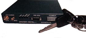
The price of the LLR system is the same regardless of whether you set it up for streaming or pinging operation. The mobile modem shown at the left and the companion transceiver with associated antennas can easily be mounted in any vehicle. The price of the mobile unit is slightly higher than the SilentPartner system ($995 excluding installation versus $700 for the SilentPartner). The base unit with associated link (either Canopy or packet radio), the central base station with antenna, software and maps is $9,995 (a little more than the $1,400 base unit used with SilentPartner).
Additional information on the Canopy system is available at www.unwirednow.com in the BROADBAND WIRELESS section. Additional information on packet radio is available at http://www.tapr.org/tapr/html/pktf.html.
As a general rule, we prefer to use the Canopy system as a link between your tower and your office since the broadband capability allows you to use this link to convey other information. For instance, the Canopy system has the capacity of handling up to 10 megabytes of data. That means that you can eliminate leased telephone lines to the tower site. With the proper sensors, you can send back information to report unauthorized entry, equipment malfunctions, tower light conditions, even power failure. Thats the good news. The bad news (and it isnt always bad) is that you must have a clear line of sight path between your dispatch center and the tower. This can be confirmed by conducting a path survey. If we cant use the Canopy system, we use packet repeaters to provide the connection between your tower and the dispatch center. Either way, the cost is the same.
To summarize, the Stationary Information system is primarily for location display. The Administrative Reporting (SilentPartner) is used to provide activity reports, and the Live Location Reporting system is used to either follow the movement of vehicles in live or near live time or to selectively determine the location of a single vehicle or an entire fleet as desired. There are no monthly airtime charges associated with any of these systems.
Lastly, the Carrier Based Live location system (CBL) is a fee based GPS location reporting system offered by wireless service providers such as Alltel, Cingular (Mobitex) using a technology known as CDPD (Cellular Digital Packet Data) or CDPD. This is an older technology using the analog cellular networks developed during the 80s. The coverage is very good although the data speed is very slow. This technology is the basis for vehicular location and assistance programs such as the General Motors OnStar system and similar programs by other automobile manufacturers.
CBL systems were widely used for text messaging (Blackberry and the Motorola T900 2-way pagers being well known examples of equipment used on this system). A few police departments, notably those in the Alltel CDPD coverage area used this service until the FCC mandated that all of the older CDPD systems be upgraded from analog to digital. This basically stopped all growth of both analog data systems and systems such as OnStar (commonly known as a telenetics application). The original systems typically offered unlimited data of any type (mobile data, GPS, or 2-way text messaging) for $50 monthly.
Today, the alternative to analog CBL is the AT&T and T-Mobile GPRS systems as well as the TDMA systems offered by Nextel and SouthernLINC, plus the CDMA systems offered Sprint and Verizon with average data speeds up to ten times higher than the old CDPD networks. Cost is slightly higher ($50 - $80 monthly for unlimited service subject in some cases to quantity discounts ). Digital systems have been initially designed for use in metropolitan areas, on Interstate and Federal highways with little or no coverage in rural areas. Still, if you are in an area served by a high speed digital network, choosing CBL can be a good choice for both voice and data communications. Regrettably, there are no networks in place to support GPS at this time (November 2003). However, that is about to change!
 |